Hyderabad: City-based Garudalytics has devised a voice-based mapping system called Garudalytics Smart Mapping (GSM)
This uses location intelligence with artificial intelligence and is capable of handling voice commands and perform multiple operations like query, buffer, nearby analysis, swipe between the layers, export layer and other. It provides 2D and 3D visual interactions with the data, converts file formats from one environment to other with a simple and easy voice command.
GSM is independent of hardware, device, software, and compatibility. It is light and consumes less memory, said Dr VSS Kiran, Garudalytics CEO.
The web-based geographic information system (GIS) is improving and taking over the desktop GIS. A desktop-GIS based application neither can be accessible on a server or nor can be remotely accessed. It is only restricted to one’s personal computer. An Internet-based GIS application is mobile, powerful, flexible and easier to share geographic data, he said about GSM.
“There is no platform to help the visually impaired in query, analysis and mapping of geospatial data. Most of the online GIS applications do not comply with certain provisions (like Americans with Disabilities Act). GSM is easy to access from desktop, laptop, mobile, or a tab. GSM can be accessed by paying hourly or minute-based usage,” said Kiran.
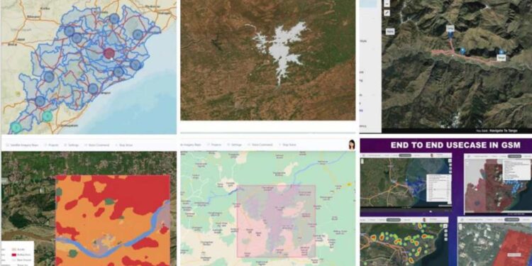
“We used our platform to analyse hotspots of road accidents. It can be used to create a land use land cover (LUKC) map by downloading the geospatial datasets, for water body extraction. GSM can also be used for creating a route map using only voice commands. The route map is generated with distances and directions within a few seconds,” he said.
On the ease of use, he said conventionally external softwares are needed to convert file extensions but GSM allows drag-and drop. It can be used to create heatmaps, marker clustering and queries with geospatial data.
Garudalytics had earlier showcased a solution that allows the forest department officials to know about waterbodies or attempts for deforestation. The same can be used for animal count and movement data. It has also got enquiries for waterbody management solutions from Governments.